Save this image free of charge
in 800 pixels for layout use
(right click, Save as...)
|
|
Ref : T02901
Theme :
Looking at Earth - Volcanos (181 images)
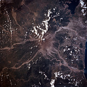
Title : Mount Pinatubo Volcano, Philippines August 1992
Caption :
Mount Pinatubo Volcano, after its eruption in June and August of 1991, is considered to be one of the world’s most violent and destructive volcanic events of the 20th century. This south-looking view shows the ash around the volcano itself, plus the destructive lahars radiating out in all directions from the volcano’s summit. Mount Pinatubo is one of 22 active volcanoes dotting the Philippines. The volcano lies in the central portion of the Zambales Range, a north-northwest-trending mountain belt that extends 137 miles (220 km) from Lingayan Gulf in the north to the Bataan Peninsula in the south. Volcanic activity occurred as early as seven million years in the Zambales Range and Mount Pinatubo has been active for the last one million years. In June 1991 after more than 600 years of slumber, Pinatubo erupted so violently that more than 1.8 trillion cubic feet (5 billion cubic meters) of ash and pyroclastic debris were ejected from the volcano. This debris produced an eruption column 11 miles (18 km) wide at the base of the volcano, and projected debris that reached an altitude of 18 miles (30 km) above the volcano. In the eruption wake, over 840 people were killed, and nearly 200 injured, and 25 reported missing along with destroying 250000 acres (100000 hectares) of prime agricultural land by the ash falls and numerous lahars. Some of the ash falls measured were as deep as 10 feet (3 meters). The large United States Clark Air Force Base (left center) was forced to close and remains closed today. Minor eruptions continue to occur at Mount Pinatubo.
|
|

